Back

Fascinatingly, on the website of the Office of the Director of National Intelligence (i.e, James Clapper) where the interview is dutifully reprinted in full, this quote comes out as “most truthful or least most untruthful manner.”

David L. Lewis, Science for Sale.
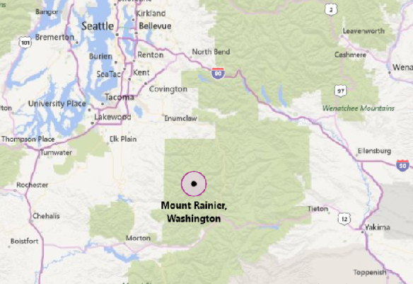
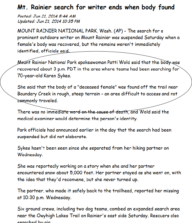
Like anyone following Google’s view of the news back in June of 2014, I become interested in the fate of Karen Sykes. Her strange disappearance made headline news in all the major papers I was reading. She was prominent and widely admired for her hiking and writing abilities. And gone missing in her favorite place, the trails around Mount Rainier.
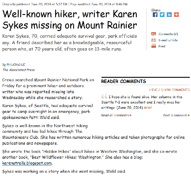
She was reported missing at 10.30 pm Wednesday the 18th. The screen clip below is from the Seattle Times of Friday the 20th.
The same reporter, Phuong Le, had a story I picked up on in the Christian Science Monitor the next day in which these paragraphs appeared:
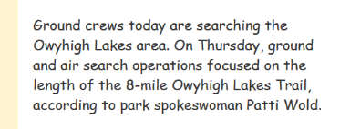
A crew in a helicopter and about 30 people on the ground searched steep, rugged terrain in the Owyhigh Lakes area for a second day Friday. They are focused along the length of the 8-mile Owyhigh Lakes Trail.
Sykes had adequate survival gear to camp overnight in an emergency, park spokeswoman Patti Wold said.
Safety concerns for Sykes and search crews include snow bridges, tree wells and steep, wet, slippery terrain, Wold said. A searcher was hurt Thursday when he punched through a snow bridge and was airlifted out of the search area.
Click the screen capture above to read the whole story and get a proper feel for the really extensive experience and high level of skill Ms Sykes had, as well as the respect and affection she was held in by the Seattle community. The story is from the Seattle Times, for whom she sometimes wrote.
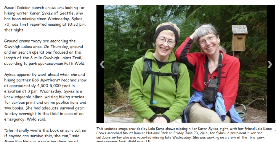
From the following story we learn at least two interesting facts: that the couple began their hike from the Deer Creek trailhead (which helps location on maps that follow) and that another experienced hiker and good friend of Karen finds it as baffling as I do that such a pro would continue in snow in such a place without a companion. That is, alone on a trail where “A searcher was hurt Thursday when he punched through a snow bridge and was airlifted out of the search area.”
As for being alone, we have this from the same Phuong Le story linked earlier (see here) –
Sykes hiked ahead of her partner Wednesday when the two reached snow level at an elevation of about 5,000 feet on the east side of the mountain, Wold said. She was reported overdue several hours later.
The Seattle Times reported:
Don Geyer, a friend of Sykes’, said she and her partner Bob Morthorst planned a day hike on Wednesday up the Owyhigh Lakes Trail for a piece she was writing. At around 5,000 feet in elevation, he said Morthorst took a lunch break while Sykes continued on, saying that she would be back in an hour; she would meet him on the way down.
She couldn’t go far, Geyer said, because the trail was covered in snow.
Morthorst reported her as overdue at around 10:30 p.m.
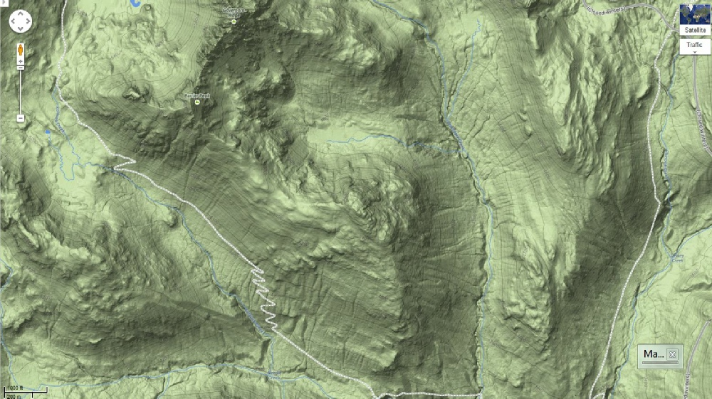
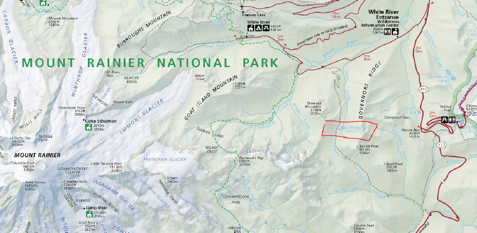
Let’s look at some maps before we go farther:
Shifting now to a large-scale Park map:
I’ll enlarge the right side of that map to clarify what is going on when Sykes’ companion and life partner Robert Morthorst takes a lunch break while she continues on. First, I think of this wider setting for this extraordinary hiker. She had gone on through snow on this trail back in 2004 when she had approached the lakes from the other end of the trail, the White River or north side. She reported this in her hiking blog published in the Seattle Post-Intelligencer on June 30, 2004:
For most, hiking to and from Owyhigh Lakes from the White River Road trailhead is recommended, as it is a shorter approach and conditions beyond Kotsuck Pass are not known. From what I could see, much of that route is still under snow, though it is melting rapidly.
This suggests that she may have wanted to make a parallel hike, indeed through snow, here in 2014, but coming up the trail from the Deer Creek side, to make a nice bookend to go with her 2004 report coming from the other side. In any case, we know that on this day, she and Robert had parked their car at the trailhead on SH 123 and hiked to about 5,000 feet where they encountered snow. That turns out to be in the vicinity of the several sharp switchbacks that show in this enlarged version of the map above:
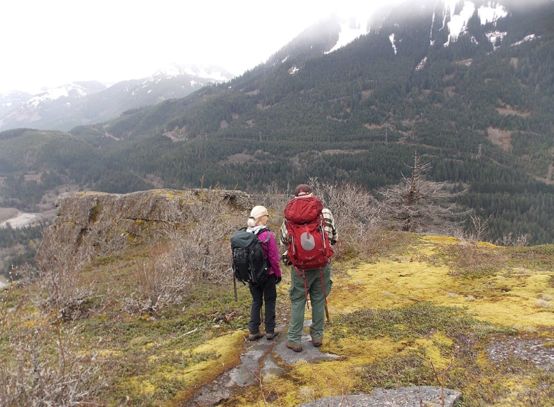
Karen Sykes’ Facebook page is still up (on 11-28-15), and there I found the picture I place below (it is cleared for the public) from April 23, 2014. She identifies the trail as “a bootleg trail off I90,” which puts it 20 or 30 miles northeast of the Owyhigh Lakes. The people in the photo are not identified, but likely are Karen and Robert.
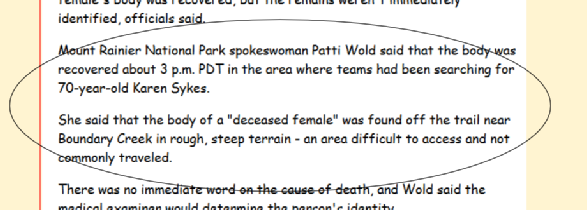
Returning now to the narrative of the multi-day search for Karen Sykes, we find that what looks at first like it should be a fairly easy search – surely just along this well defined trail and downwards in the event of a fall – is actually quite difficult. The story was in the headlines for about three days. She was reported missing at 10.30 pm on June 18th, and in the afternoon of June 20, a female body, later identified as the hiker’s, is found. Here is an AP story from the next day morning.
Since I’ve done some backpacking in the mountains myself, I was quite interested in the details of the location where she was found and the question of what sort of mishap might have gotten her wherever she was found. My interests in the details, however, were not shared by the news media. This surprised me, as I would have at least expected to hear that she had dropped through a snow bridge, been trapped somehow or perhaps broken a leg. (One of the early stories in fact mentioned that a searcher had met this fate.) Maybe she slipped and tumbled down to death or injury too severe to climb out of. This sort of thing is of interest to me. One thinks also of bear and mountain lions. Perhaps there are wolves. But no luck. None of the stories of the 21st or later filled in these details. I have to say that I found this and still do quite remarkable. I can’t be the only newspaper reader who has been out in the mountains with family, friends or alone. It seemed odd to me that reporters did not think this sort of thing interesting.
Poking around as I was for some detail as to how she met her death I came across a highly interesting comment on one of the stories about her death.
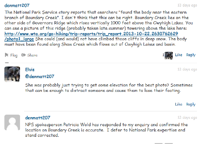
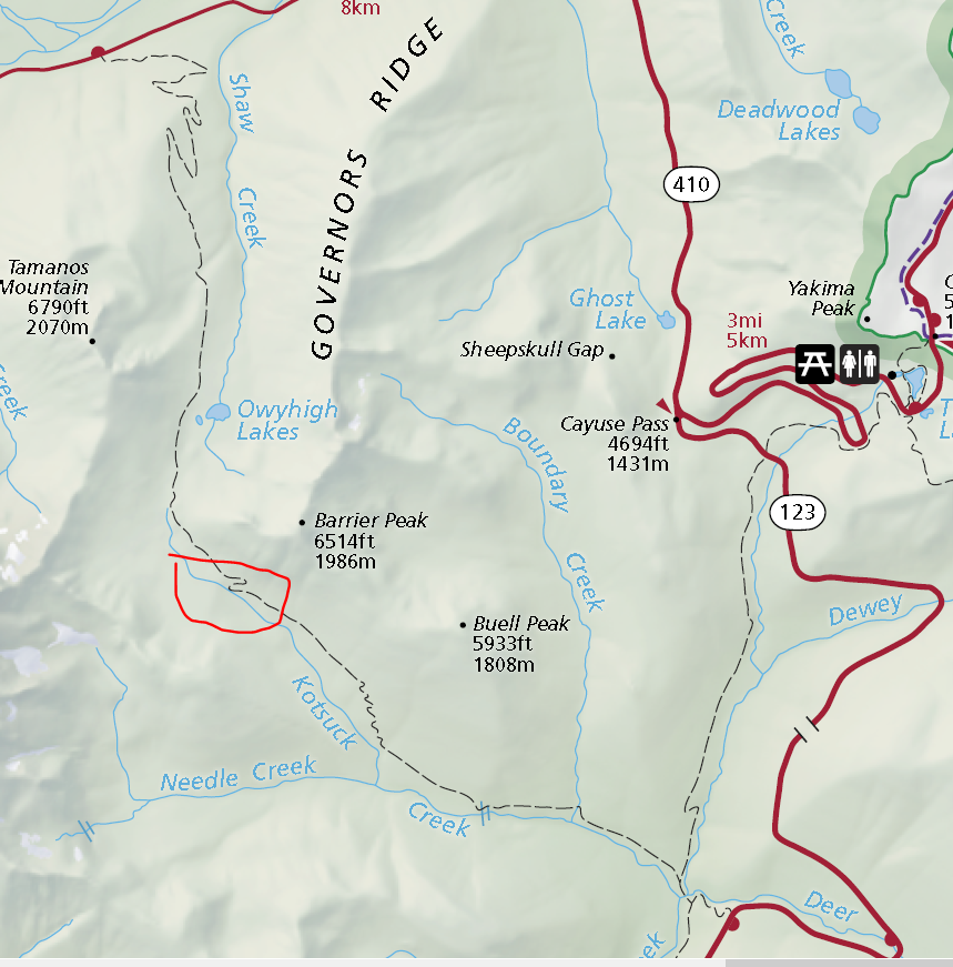
At the time I ran across this comment by denmatt207, I had no idea where Boundary Creek was. I had not looked at the nice Park map I’ve put in above. Denmatt207 is quite right about the thousand-foot cliffs.
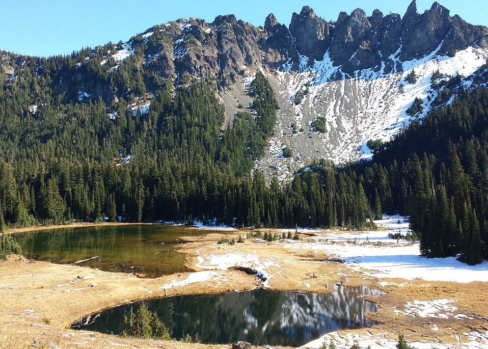
The X on the right marks the point where (from other reports I have not yet quoted from) the body was found. That’s 2.3 miles as the crow flies from where she and Robert separated. But the distance doesn’t tell the story – it’s the 1200 to 1000-foot height above the trail that the ridge between Barrier Peak and Buell Peak presents that offers a real barrier to anyone’s imagination in telling the story of how Karen Sykes might have gotten over there. Through snow. This ridge is really intimidating. Here are some photos from the Owyhigh Lake area. The point where Karen would have separated from Robert is off to the right, but she was, of course, originally headed along the trail towards the lakes.
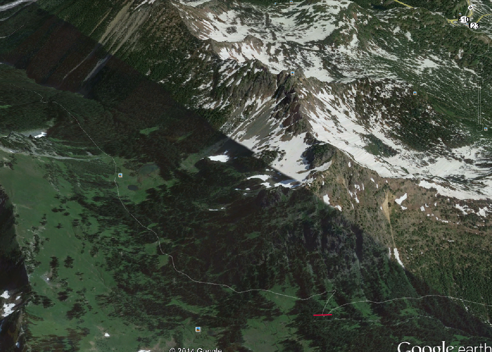
Off to the right we have what you can see in the Google Earth clip below. The trail towards the lakes is in white. A small blue-white photo icon shows where the lakes are found (and see my white arrow). The red mark to the right and down from there is about where she and Robert separated –
At around 5,000 feet in elevation, he said Morthorst took a lunch break while Sykes continued on, saying that she would be back in an hour; she would meet him on the way down.
We must also remember that there was snow at the red mark. It can only have been deeper on the way up the side of the ridge, nearly vertically, and then there would be the very rough terrain across the top, still through the snow nearly two miles and down into the next valley to get to the other side of Barrier Creek. Without a trail.
That no reporter was interested enough in the unprecedented strangeness, not to say near impossibility of it, to write any kind of story on it is what I find disturbing. Indeed I feel some sort of cognitive dissonance about it. The strongest statement I found in scouring through dozens of news reports was the one already given —
Of course, they had not originally been searching in that area at all. Recall the early news reports:
Indeed whoever would have thought originally to look over Governors Ridge two miles to the east? And whatever could have happened to take this brilliantly healthy and totally outdoors-savvy woman where she was found?
But, as I say, the yet more incredible fact about this story is that none of the major papers that got so interested in it for three days running, felt it worth looking into the strangeness of where she was found and how she got there.

Patti Wold, Park spokeswoman, states that the pair of hikers encountered snow at “an elevation of about 5,000 feet.” I mark that point with a red line. After that last dogleg, the trail continues fairly level for a little less than a mile to the Owyhigh lakes themselves.


